We were back camping at the Las Cienegas National Conservation Area after making the short run over to Hot Well Dunes for a while. It was time for a change of scenery, so when a windy day was upon us, it was a good time for a road trip!
Solar panels were all laid flat as a precaution because of the strong and gusting winds.
After an hour's drive eastward on the I-10, some of the Dragoon mountains came into view.
Unlike what this sign indicates, we took a slightly longer approach to our intended destination - the Chiricahua National Monument. We turned off the interstate on highway 191 down through Cochise, Sunsites, and Sunizona, down near where Al and Kelly were ranch-sitting for a few years, and where I first met them. I wanted to make it a circle route as much as possible.
It may be hard to see in these photos, but there were full-on dust storms happening anywhere there was not vegetation to contain the dust.

Just prior to the monument entrance, we headed down the Pinery Canyon road to check the options for boondocking, as we had previously camped out that way. Unfortunately, the washboard was so brutal, I didn't want to drive the truck on it, let alone subject the 5th wheel to it at a later date. :-(
We got to the Chiricahua entry gate, which was not operating. Not sure if fee collection has been suspended because of Covid, or whether it will remain free in the future?
The campground inside the monument (full) also has a length restriction,
required by some steep, narrow washes inside the campground.
The amazing rock formations and scenery begin just shortly beyond the Visitor Center.
There are a few pull-offs, but it can be difficult to get good photos because of the thick trees along the road.
The road climbs and climbs to higher elevations, and eventually breaks out with great views to the east, and back to the west.
After checking out Massai Point at the end of the park road, we headed for the trailhead for the Sugarloaf Mountain fire lookout. I had hiked up there several years ago and wanted to do it again.
It had rained the previous day, and I found that at these higher elevations there had also been some snow. In the interests of science, I measured the dump with my hiking pole and determined that there was a full 10cm (6 inches) of snow on the ground!
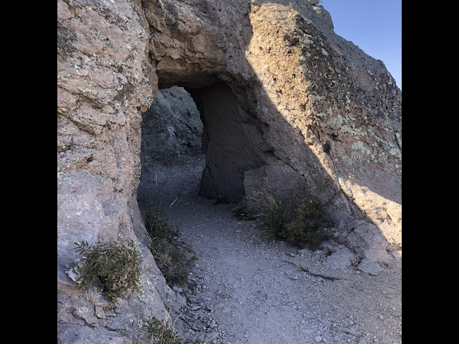
 The trail up to the lookout was apparently constructed by conservation corp workers, who managed to cut this short tunnel out of the rock face. I'm guessing that supplies to build and maintain the lookout were likely hauled up by packhorses back in the day.
While the lookout does not appear to have been active for years, the structure seems to host some radio repeater equipment.
Winds were really howling up there, and you had to keep the hat locked in place to avoid losing it!
Back in the day, the lookout obviously collected rainwater from the roof in a small cistern along the side.
Back in Las Cienegas Conservation Area, with the high winds and extreme fire hazard, I was worried about this fire I spotted a few miles away. All the grass was tinder-dry, and there was a Red Flag fire warning in the area at the time.
It only lasted a few hours, so I guess they got it under control. Perhaps it was surrounded by roads or fields?
In other news -
The big GM just passed yet another milestone, and turned over 500,000km (about 311k miles). It just keeps purring along like new, after 14 years, never using any oil or having any other major problems. It's been from Alaska (twice), to the Texas gulf coast, and from San Diego to Newfoundland, and everywhere in between, usually towing the fifth wheel or with the camper on it.
Hailey and I are sure missing all the snow and cold temperatures back home!
Next post: Looking for camping spots in Ironwood Forest National Monument ...


The fire burned about 30 acres and sadly two homes. Thanks for the update on the Pinery Canyon road--we drove it early in the season and it was awful then. We live near Sunsites.
ReplyDeleteThanks for that update. Sorry to hear that homes were involved :-( I think you are friends of John & Brenda?
DeleteYes Ivan, that is correct, we are friends of John and Brenda.
DeleteThat hike up to the mountaintop is my favorite. The views are great. What a mileage milestone. Best truck ever.
ReplyDeleteOur Fire Lookouts up here (Wa-Ore-Id-Mt) are way up in the air, I've gotten dizzy climbing some of them.
ReplyDeleteMy 2013 Silverado had -0- issues, then I took it in for a simple service.I got it home and it only has 60,000 miles, the rear main seal was leaking...DANG!
I've never towed much and only had it up to 128 mph a couple of times..
Oh Well.....(HWY 97 along the Columbia with no side streets)....(;+)...
Your drive and photos heading into the Chiricahua Monument sure brought back memories for me and yes I remember those trees along the road obscuring those scenic rock spires along the way. That is pretty amazing about your truck traveling all those miles pretty much trouble free. That whole Cochise County area feels like our old stomping grounds. I sure hope we can make it down there again at least one more time. Nice Hailey sunset photos.
ReplyDeleteI thought I would comment on your CCC construction. I was a park ranger at Chiricahua in the 1970's and cleaned up all traces of the old CCC camp at the silver spur spring. My understanding was cement and other supplies (ie tools, water, building materials) were transported by a fire brigade. Supposedly, an 80 man crew spread out on the trail and passed each item upstream stockpiling then repeated the process. Anyway, thanks for sharing your travels.......Mike
ReplyDeleteWow, thanks Mike, for for that first-hand information on the work of the CCC!
Delete